Pound of Rabbassoles
leicht
Navigieren
Navigieren
Hol diese Tour auf dein Handy
Pound of Rabbassoles
leicht
Wanderung
7,37
km
QR-Code scannen und Navigation in der bergfex App beginnen

Wandern & Tracking


Pound of Rabbassoles
leicht
Distanz
7,37
km
Dauer
04:00
h
Aufstieg
362
hm
Seehöhe
1.580 -
2.110
m
Track-Download
Pound of Rabbassoles
leicht
Wanderung
7,37
km
Access: On leaving Mijanès, take the straight towards Col de Pailhères/Ax les Thermes and at the first bend, take the forest track straight ahead to the "new" La Restanque parking lot.
Autor
Bereitgestellt von Ariège Pyrénées Tourisme
Die Tour Pound of Rabbassoles wird von outdooractive.com bereitgestellt.

Weginformationen
Wegverlauf
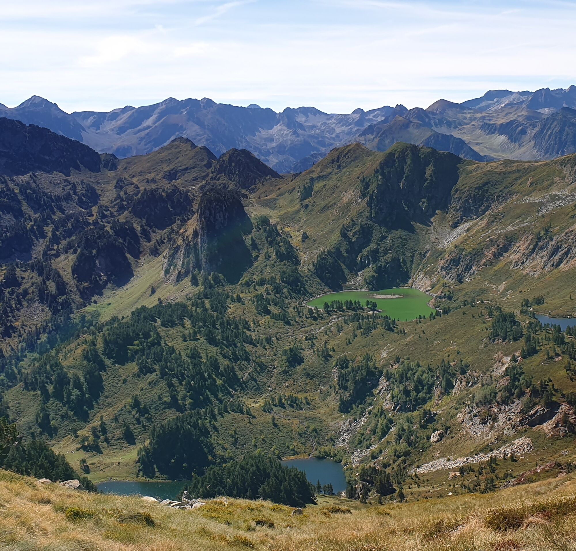
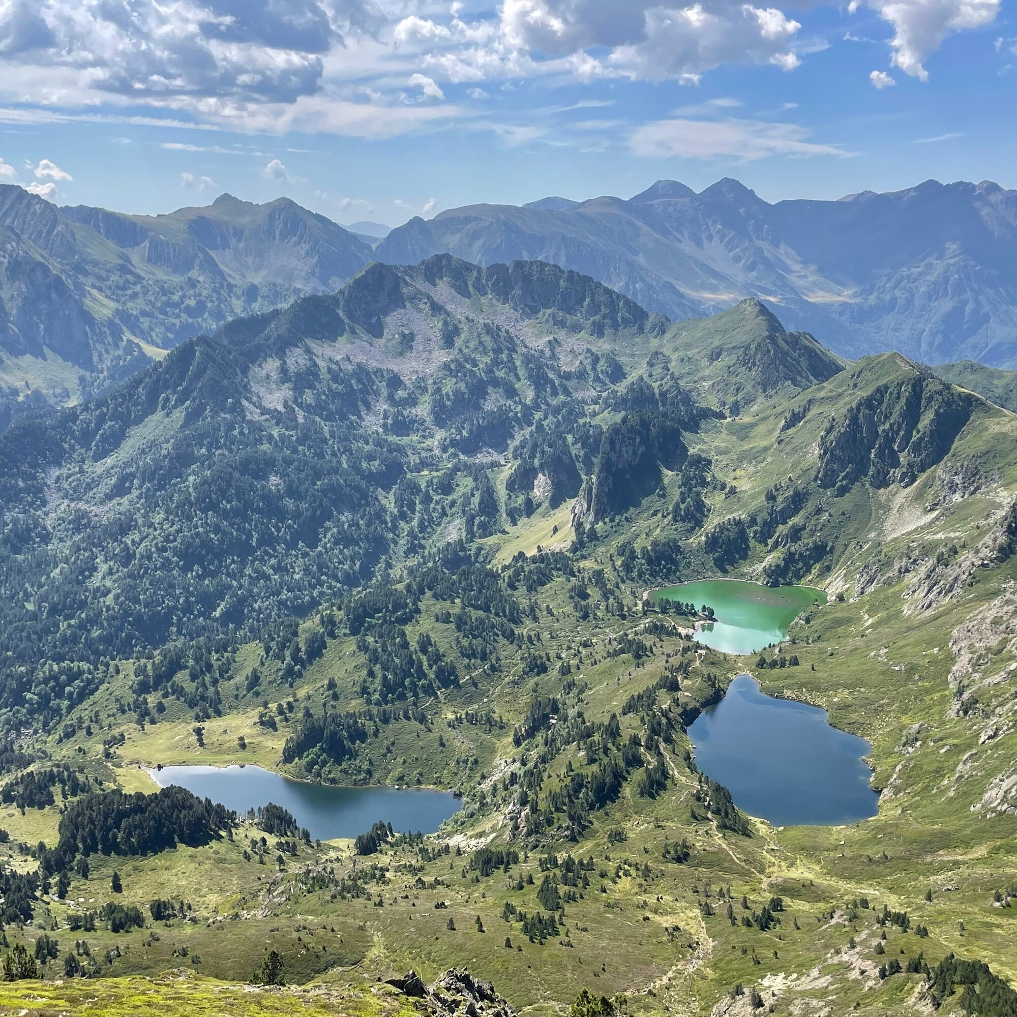
(D/A) From the parking lot, take the path at the signposts, towards La Restanque. Arrive at a clearing with picnic tables. picnic tables, turn right towards Les Rabassoles.
0h30 - The path leads to the foot of a stream. Turn right to cross over the bridge. Continue uphill. At Pla d'Artounant, continue straight on towards Les Rabassoles. Follow the stream. At a bend, ford the stream using large stones. stones. Continue for 150m, then ford the stream again on stones stones at a large coniferous tree, then head uphill.
1h00 - Arrive at the Rabassoles pond. Turn left to ford the pond. Take the path that climbs up to overlook the lake. At the stream, turn left to reach Etang Bleu.
1h20 - Walk along the lake to the left on the GR7B and follow the path which climbs steeply. After crossing a small pass, descend to Wareck pond. Continue straight ahead on the path, walking along the slope. At the Col de Llausses, leave the GR 7B down to the left, towards l'Estagnet pond.
2h40 - Walk alongside l'Estagnet pond, then continue on the path which winding downhill. At the bottom of the descent, follow the winding path right of the stream to a wetland. Walk alongside it and enter the meadow. Stay on the left-hand edge of the meadow and, at a small ridge, follow the left-hand path downhill to the intersection. Return to the path abandoned at the driveway back to the parking lot.
4h. - Restanque parking lot
Noch keine Bewertungen
Beliebte Touren in der Nähe
GR10 Pyrenäenweg Etappe 45
mittelFernwanderweg 16,9 kmC 3. Etappe Artigues-Tarascon, Okzitanien/Frankreich
schwerRadfahren 63,2 kmPic de la camisette 2426m par les etangs et l'epave
mittelWanderung 13,3 kmThe Perics tour
mittelWanderung 47,5 km- 4,0
Pic de Tarbesou - Carena Runde - Etang Noir et Blue
mittelWanderung 12,3 km Le Pic du Tarbésou
mittelWanderung 2,82 kmCyclosport-Strecke 11 - Die Radtour durch Ariège - Etappe 4: von Prades nach Ax-les-Thermes
schwerRennrad 68,4 kmLa Grande Traversée VTT Ariège Pyrénées FFC Label
schwerMountainbike 32,5 kmDie VTT-Querung der Ariège - Etappe 01: Ax-les-Thermes zur Schutzhütte Chioula
schwerMountainbike 17,6 kmÉtang du Laurenti
leichtWanderung 5,57 km

Wandern & Tracking

Über 550.000 Tourenvorschläge, detailliertes Kartenmaterial und ein intuitiver Routenplaner machen die App zum Must-have für alle Naturbegeisterten.

Verpasse keine Angebote und Inspirationen für deinen nächsten Urlaub
Zum Newsletter anmelden
Fehler
Ein Fehler ist aufgetreten. Bitte versuche es erneut.Vielen Dank für deine Anmeldung
Deine E-Mail-Adresse wurde in den Verteiler eingetragen.
Touren in ganz Europa
Österreich Schweiz Deutschland Italien Slowenien Frankreich Niederlande Belgien Polen Liechtenstein Tschechien Slowakei Spanien Kroatien Bosnien und Herzegowina Luxemburg Andorra Portugal Island Vereinigtes Königreich Irland Griechenland Albanien Nordmazedonien Malta Norwegen Montenegro Moldau Kosovo Ungarn San Marino Rumänien Estland Lettland Belarus Zypern Litauen Serbien Bulgarien Monaco Dänemark Schweden Finnland